MoroniMoroni

Inicio Volver Buscador Av. Google Maps Otras WEBS FORO

.

Nombre:

Canal de Mánchester

Otro:

Localización:

Récord: 58 km

Tipo: Canales

Categoría:

Foto:

The Ship Canal at Easham, where it joins up the River Mersey before continuing the journey to the North Sea. Canal de Mánchester 1

Voto:

No hay votos

Continente: Europa

País: Reino Unido

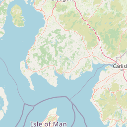
Localización: Estuario del Mersey cerca de Liverpool y Mánchester

Año: 1894

Estado: Terminado

Descripción:21 / 03 / 2012

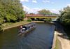
Navegar por el Manchester Ship Canal

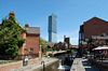
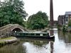
Manchester Ship Canal tiene más de cien años pero goza de una salud envidiable.

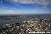
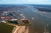
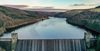
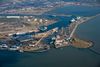
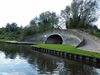
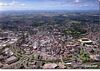
Desde el estuario del río Mersey, cerca de Liverpool, hasta el centro de Manchester, uniendo ambas ciudades a lo largo de 58 kilómetros, transcurre el Manchester Ship Canal, uno de los primeros creados en esta ciudad inglesa y de los más importantes de la red de canales británica.

Eastham Locks Wirral, Merseyside. Canal de Mánchester 2

Eastham Locks Wirral, Merseyside. Canal de Mánchester 3

Nuuk Maersk Entering Eastham Locks. Canal de Mánchester 4

Nuuk Maersk Entering Eastham Locks. Canal de Mánchester 5

Upper Mersey Estuary. Canal de Mánchester 6

River Mersey and the Manchester Ship Canal aerial photograph view of the canal and mud flats. Canal de Mánchester 7

The Gowy flows Under the Ship Canal, past the site of Stanlow Abbey into the Mersey. Canal de Mánchester 8

Manchester Ship Canal at Ellesmere Port, on the estuary of the River Mersey, Cheshire. Canal de Mánchester 9

Oil Pier at Stanlow Oil Refinery. Canal de Mánchester 10

The ship canal alongside the Mersey between Stanlow and Runcorn, looking east. Canal de Mánchester 11

Weston Point from the North. The Manchester Ship Canal enters top right with the River Weaver joining from the top left. The Mersey is to the right and the lock system can be seen. To the left of the canal are Weston Point docks, serving the chemical complexes here. Canal de Mánchester 12

Runcorn from the South-East. Canal de Mánchester 13

Canal Side, Runcorn. Canal de Mánchester 14

Canal Side, Runcorn. Canal de Mánchester 15

Runcorn. Canal de Mánchester 16

Canal de Mánchester 17

Silver Jubilee Bridge and Runcorn Railway Bridge. Canal de Mánchester 18

Runcorn Jubilee Bridge. Canal de Mánchester 19

Silver Jubilee Bridge & Runcorn Railway Bridge, Runcorn Gap, River Mersey. Canal de Mánchester 20

Runcorn Old Quay Lock, Runcorn Gap, Manchester Ship Canal, River Mersey, Cheshire. Canal de Mánchester 21

Runcorn. Canal de Mánchester 22

Old Quay Swing Bridge. Canal de Mánchester 23

Moore Lane Swing Bridge. Canal de Mánchester 24

Acton Grange Railway Viaduct. Canal de Mánchester 25

Chester Road Swing Bridge. Canal de Mánchester 26

Wilderspool Causeway. London Road A49 Swing Bridge. Canal de Mánchester 27

Cantilever High Level Bridge. Canal de Mánchester 28

Arklow Field' Knutsford Road Swing Bridge. Canal de Mánchester 29

Manchester Ship Canal showing Latchford Viaduct and Latchford Locks. Canal de Mánchester 30

Latchford Railway Viaduct, Manchester Ship Canal, near Warrington, Cheshire. Canal de Mánchester 31

El Manchester Ship Canal fue inaugurado por la Reina Victoria en 1894 tras seis años de construcción y actualmente soporta 40 millones de toneladas de carga repartidas en 15.000 barcos al año.

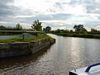
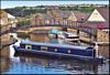
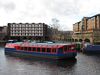
Pero no sólo de carga industrial vive el canal, el Manchester Ship Canal también tiene su sección turística. Y es que los más curiosos pueden recorrer este canal a bordo de un crucero en un viaje donde el agua y la naturaleza cobran una especial relevancia.

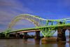
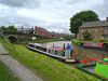
Una de las empresas que ofrecen este viaje es Mersey Ferries que invita a un recorrido en sentido Manchester-Liverpool o al contrario. El crucero tiene una duración de seis horas y durante este tiempo la tripulación del barco deleitará a los pasajeros con la historia del canal y su importancia en Manchester y el Norte de Inglaterra. Además, narrarán cómo y cuándo fueron construidos algunos de los puentes y esclusas más representativos del canal, algunos de los cuales se construyeron hace más de 100 años. Por otra parte, especial mención merece la arquitectura de la región por la que pasa el canal y las vistas sobre la naturaleza que ofrece este crucero.

Desde Manchester este crucero sale de Salford Quays y llega al puerto de Liverpool donde un autobús recoge a los pasajeros para llevarlos de regreso a Manchester, al punto de partida. Si se quieres realizar la travesía al contrario, en Liverpool el crucero parte de Seacomb o, diez minutos más tarde, de Woodside. En este caso también un autobús recogerá a los pasajeros en Manchester para llevarlos de regreso a Liverpool.

El precio del crucero es de ₤37 para adultos y ₤35 en precio reducido.

http://viajar.elperiodico.com/destinos/europa/reino-unido/inglaterra/manchester/navegar-por-el-manchester-ship-canal

Latchford Viaduct. Canal de Mánchester 32

Latchford Locks, Manchester Ship Canal, Warrington. Canal de Mánchester 33

Latchford Locks. Canal de Mánchester 34

Manchester Ship Canal aerial photograph of the Happy Falcon navigating the Manchester Ship Canal about to pass under the M6 motorway Thelwall viaduct. Canal de Mánchester 35

Manchester Ship Canal aerial photograph of the Happy Falcon navigating the Manchester Ship Canal about to pass under the M6 motorway Thelwall viaduct. Canal de Mánchester 36

Thelwall Viaduct. Canal de Mánchester 37

River Mersey leaves the Manchester Ship Canal. Canal de Mánchester 38

Warburton Bridge. Canal de Mánchester 39

Cadishead Railway Viaduct (disused). Canal de Mánchester 35

Carrington Power Station, Carrington Plain, River Mersey the Ship Canal with Manchester and the Trafford Park Industrial Estate in the background. Canal de Mánchester 41

Peel container Terminal Irlam. Canal de Mánchester 42

Manchester high level aerial photograph of The Manchester Ship canal and the container ship Thea 11 transiting the canal to Irlam locks and turning around to return to the Liverpool and Manchester shuttle Irlam container terminal part of Peel Ports. Canal de Mánchester 43

Confluence of River Mersey and Manchester Ship Canal. A HDR Panoramic image (3 scenes) of the confluence of the Mersey and Ship Canal. To the left of the image is Irlam Railway Viaduct, which carries the Liverpool-Warrington-Manchester line across the canal. Irlam Locks can be seen in the distance, behind the viaduct. The power lines head to the former site of Carrington Power Station. Canal de Mánchester 44

Irlam Viaduct. Canal de Mánchester 40

The Manchester Ship Canal, viewed from the Irlam railway viaduct. Canal de Mánchester 46

Manchester aerial photograph of The Manchester Ship canal and the container ship Thea 11 transiting the canal to Irlam locks and turning around to return to the Liverpool and Manchester shuttle Irlam container terminal part of Peel Ports. Canal de Mánchester 47

Manchester aerial photograph of The Manchester Ship canal and the container ship Thea 11 transiting the canal to Irlam locks and turning around to return to the Liverpool and Manchester shuttle Irlam container terminal part of Peel Ports. Canal de Mánchester 48

Port of Salford aerial photograph of the development of the UK first Trimodal inland port facility. Canal de Mánchester 49

Barton Locks. Canal de Mánchester 50

Barton Locks. Canal de Mánchester 51

Manchester Ship Canal

The Manchester Ship Canal is not considered a leisure waterway and the incompatibility of large ships and small boats means that hired vessels are not usually permitted. Boat owners must seek permission to use the canal from the Manchester Ship Canal Company, proving that their boat is seaworthy, insured and has the required safety equipment on board. As commercial traffic has decreased, the regulations have become less onerous. There are links to the River Mersey at Eastham, the Shropshire Union Canal at Ellesmere Port, the River Weaver and Weaver Navigation at Western Point and the Bridgewater Canal via the lock in Pomona No 3 Dock. The Canal is 37.4 miles (60.1 km) long and has 5 locks.

The maximum size of craft that can navigate throughout the Canal, to Woden Street Footbridge, Manchester, is

length: 600' (182.8 metres)

beam: 65' (19.8 metres)

height: 70' (21.3 metres)

draught: 28' (8.5 metres)

Above Woden Street footbridge and into the upper reaches of the river Irwell (the inland most 1.4 miles - 2.2 km of navigation), craft are restricted to

beam: 25' (7.6 metres)

height: 15' (4.5 metres)

draught: 4' 6" (1.3 metres)

https://www.waterways.org.uk/waterways/canals_rivers/manchester_ship_canal/manchester_ship_canal

Barton Locks. Canal de Mánchester 52

Port of Salford aerial photograph of the development of the UK first Trimodal inland port facility. Canal de Mánchester 53

Manchester wide angle aerial photograph of the Manchester ship canal and Barton high level bridge M60. Canal de Mánchester 54

Aerial view of Barton-on-Irwell in 2002 looking SE showing the Barton Swing Aqueduct over the ship canal (left) and the Barton Road Swing Bridge (right). Canal de Mánchester 55

Barton Swing Bridge. Canal de Mánchester 56

Barton Swing Bridge. Canal de Mánchester 57

Barton Swing Bridge. Canal de Mánchester 58

Canals Barges, Over The Top, Barges Narrowboats, Manchester Ship, Barton Swing, Geo Tur Int. Canal de Mánchester 59

The Barton Swing Aqueduct was built in 1761. It looks up the Manchester Ship Canal through the road bridge. Canal de Mánchester 60

Aerial view of the Manchester Ship Canal running through Trafford Park. Canal de Mánchester 61

As the canal runs through Trafford Park a number of roads pass over it. The Centenary Lift Bridge built in 1994 can be seen in it's open position awaiting a ships arrival. Canal de Mánchester 62

Centenary Lift Bridge. Canal de Mánchester 63

Cenenary Lift Bridge is a vertical bridge which was opened in 1995. Canal de Mánchester 64

Salford. Canal de Mánchester 65

Mode Wheel Locks. Canal de Mánchester 66

Mode Wheel Locks. Canal de Mánchester 67

Manchester high level aerial photograph of Salford Quays and the BBC Media Manchester Manchester high level. Canal de Mánchester 68

Manchester aerial photograph looking down the Manchester Ship Canal towards the Lowry Retail Centre with BCC. Basins Mode Wheel. Canal de Mánchester 69

Manchester aerial photograph looking across Trafford Wharf Road towards the Manchester Ship Canal and the Lowry Retail Centre with BCC Media City and ITV new Coronation Street Film Set in the foreground Trafford Park Industrial Estate. Canal de Mánchester 70

Manchester high level view of BBC Media City Salford Quay. Canal de Mánchester 71

El canal de Manchester tiene 36 millas de largo (58 km) de vía navegable en el noroeste de Inglaterra, que une a Manchester al Mar de Irlanda. Comenzando en el estuario de Mersey, cerca de Liverpool, que generalmente sigue las rutas originales de los ríos Mersey y el Irwell a través de los condados históricos de Cheshire y Lancashire. Varios conjuntos de esclusas de cerca de 60 pies (18 m) hasta Manchester, donde termina el canal. Los principales puntos de referencia a lo largo de su recorrido incluyen el acueducto oscilante de Barton, el único acueducto de oscilante en el mundo, y el Trafford Park, en primer polígono industrial planificado del mundo y sigue siendo el más grande de Europa.

https://en.wikipedia.org/wiki/Manchester_Ship_Canal

http://www.allertonoak.com/merseyFlights/SouthOfMersey.html

https://ssl.panoramio.com/photo/128251672

http://www.filmandtvlocations.co.uk/locations/msc

https://www.flickr.com/photos/northports/sets/72157649238418829

https://ssl.panoramio.com/photo/81535388

https://ssl.panoramio.com/user/5948597/tags/Manchester Ship Canal

http://skycamuk.photodeck.com/?utf8=✓&search=ship canal manchester&orientation=*ALL*&search=ship canal manchester

Salford Quays. Canal de Mánchester 72

MediaCityUK. Canal de Mánchester 73

Salford Quays lift bridge. Canal de Mánchester 74

Swing Bridge and Hi-Rise. Canal de Mánchester 75

Manchester view showing the Manchester Ship Canal Exchange Quay Pomona Strand and the old Pomona Docks and the industrial estate along Ordsall Lane. Canal de Mánchester 76

Pomona Docks. Canal de Mánchester 77

The Manchester Metrolink Eccles line crosses the Manchester Ship Canal at Pomona. The Bridgewater Canal is linked to the ship canal through Dock No.3. Canal de Mánchester 78

Woden Street Bridge, Salford. Canal de Mánchester 79

Former docks at the junction of the river Irwell and the Manchester Ship Canal. Canal de Mánchester 80

Near of Manchester Ship Canal, Bolton and Bury Canal, Salford. Canal de Mánchester 81

Near of Manchester Ship Canal. The Manchester & Salford Junction Canal enters the River Irwell under the lift bridge. The first lock is immediately behind the bridge. The River Irwell is navigable for around 1.4km (nearly a mile) upstream (to the left) of the junction. Downstream (to the right) is the junction with the Manchester, Bolton & Bury Canal, the former Hulme Locks Branch, Pomona Lock and the Manchester Ship Canal. The Manchester and Salford Junction Canal was a canal in the city of Manchester. It was originally built to provide a direct waterway between the Mersey and Irwell Navigation and the Rochdale Canal. The canal opened in 1839 and was abandoned in 1922. Canal de Mánchester 82

The navigations, canals, roads and railways of Manchester. Canal de Mánchester 83

Route of the Manchester Ship Canal. Canal de Mánchester 84

Vídeo:

Web recomendada:

Contador: 5615

Inserción: 2016-07-06 18:53:23


Lugares a visitar en un radio de 100 km (en línea recta)

Mapa de los lugares a 100 km (en línea recta)

Mostrando Registros desde el 1 hasta el 0 de un total de 0

Nick:

Email: No se publicará

Comentario: Tags HTML permitidos <blockquote>citas<strong>negrita< em>cursiva <u>subrayado<li> elemento lista <ul>ordenada<ol>numérica y sus cierres (url y saltos de línea se convierten automáticamente)

Todos los campos obligatorios

Visitas

RSSrss

Más visitados

Incorporaciones

Comentarios

Feetdreaway

Palacio Mijailovsky

скачать игру симс 3 взлом [url=

Feetdreaway

Samara

скачать мотор комбат 9 [url=

Feetdreaway

Vitebsk

мимимишки большой концерт скачать [url=

Feetdreaway

Presa y Embalse de Irkutsk

скачать игру автош [url=

МЕГАСТО

Castillo de Artá

Конвеєрна стрічка - загального призначення,...

Sin fines de lucro

xmobile phoneenglish versionVídeos

Estadísticas

Estadísticas Puertos/Aeropuertos

Récords Mundiales

Foro

MEGACONSTRUCCIONES.NET